Explore the Mallee Track
28 September 2023
- Road Trip
Mildura to Murrayville
Set off from Mildura and take in the Mallee countryside, exploring country towns, with character and charm, along the Mallee Highway towards the Victorian-South Australian border. Discover the spectacular semi-arid and sandy landscapes which encompass the North-West region of Victoria. With Mallee dunes and open skies as far as the eye can see, the Mallee Track is certainly worth the drive.
|
|
Your trip at a glanceHattah
Ouyen
Walpeup
Underbool
Cowangie
Murrayville
|
Insider tips
- Touring through our region may take you through some remote areas. Forward planning and vigilance are important and will help to ensure your experience is safe. Make sure your vehicle is in excellent mechanical condition before setting out on an outback adventure.
- Need advice on road conditions and national parks? Get in touch with Mildura Visitor Information Centre on 03 5018 8380.
Hattah
Travel time: 45 mins
Distance: 65km from Mildura
Start your journey in Mildura and travel south along the Calder Highway. Your first stop is in the small town of Hattah, the gateway to the Hattah-Kulkyne National Park (Mournpall Track, Hattah VIC). Famous for its red dirt and semi-arid shrub-like vegetation, explore this spectacular landscape and view the tranquil waters of the freshwater lakes and billabongs that are filled from the Murray. Stop by the Hattah Roadhouse (3478 Calder Highway, Hattah VIC) and grab a bite to eat for the journey. While you’re there, take a good look at the large signpost just outside the shop which points towards several cities around the world. See if you’ve been to any of these places and find out how far away they actually are!
Ouyen
Travel time: 23 mins
Distance: 35km from Hattah
From Hattah, hop back onto the highway once again and make your way to the heart of the Mallee. Ouyen is a busy dry-land farming town surrounded by beautiful natural landscapes. In the middle of town, you will see the Big Mallee Root Stump (6 Calder Highway, Ouyen VIC), the largest Mallee stump in Australia. It acts as a reminder of the difficulties faced by the European settlers in clearing the area and the agricultural significance of the town to the region. Make sure to pop into the Ouyen Mallee Bakery (28 Oke Street, Ouyen VIC) where Jeff Kennett famously declared the vanilla slice from the bakery was the best he ever tasted. If you are in need of somewhere to stretch those legs of yours, stop by Ouyen Lake (Scott Street or North West Road, Ouyen VIC) which is a fantastic spot for a walk or perhaps a nice picnic by the water.
Walpeup
Travel time: 23 mins
Distance: 30km from Ouyen
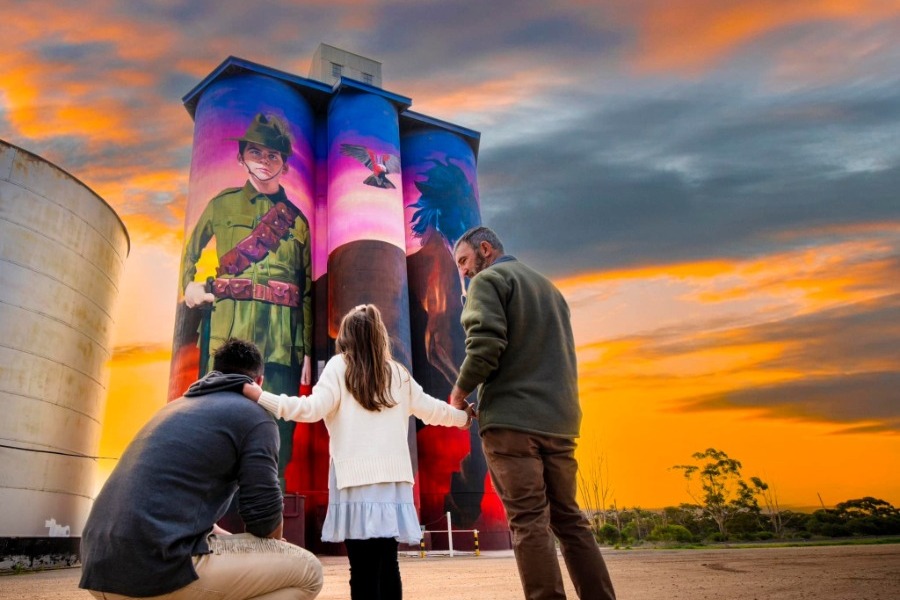
Hit the road again and make your way onto the Mallee Highway. You’ll find a few treasures along the way. From Ouyen, drive about 20 minutes to the charming town of Walpeup. It is here you will catch a glimpse of the GrainCorp Walpeup Silo (Mallee Highway, Walpeup VIC). Painted by internationally renowned artist Julian Clavijo, the silo tells the story of Walpeup local, 16-year-old Harold Thomas Bell (Wickham), who assumed a false identity and enlisted into the Australian Army in 1917. Accepted into the 4th Light Horse regiment, Harold devastatingly lost his life in the attack of Beersheba (Gaza). Also worth a visit is the Walpeup Memorial Hall (Richardson Street, Walpeup VIC) which houses a large collection of historic photographs and war memorabilia. Grab a bite to eat or a cuppa from the Walpeup General Store (Cregan Street, Walpeup VIC) and wander through the Walpeup Dryland Garden (3 Glen Street, Walpeup VIC) showcasing a range of native plants and shrubs from the local area.
Book ahead - Plan a stay along the way
Whatever your style and whatever your budget, there’s something to suit everyone. Here’s a few suggestions:
Walpeup Wayside Stop
This convenient campsite is the perfect pitstop along the Mallee Highway. Snap up a bargain with powered and unpowered sites available $10 or less. With clean facilities and a playground for kids, you’re all set.
Corner of Creagan Street & Murphy Road, Walpeup VIC. T: 03 5018 8100
Lake Crosbie Main Campground, Pink Lakes
Camp under the stars alongside the spectacular Pink Lakes. Situated in the Murray Sunset National Park, there is designated campground accessible via 2WD. No bookings are required, however you’re encouraged to be well-prepared and self-sufficient.
Access via Pink Lakes Road, Linga VIC. T: 13 19 63
Murrayville Hotel Motel
Murrayville Hotel is everything you’d want from a country pub - incredibly laid back, heritage charm and comfortable front bar. Basic but comfortable rooms are available for stays.
27 McKenzie Street, Murrayville VIC. T: 03 5095 2120
Underbool
Travel time: 13 mins
Distance: 20km from Walpeup
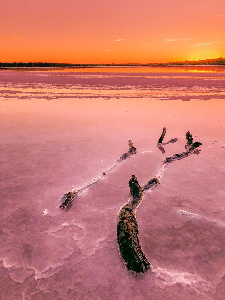
Continuing your journey, take a short drive to Underbool. Known as the ‘Gateway to the Pink Lakes’, this quaint little town is a great place to stop off on your travels, be sure to check out the Pioneer Memorial Wall (Mallee Highway, Underbool VIC) and pop into the Pink Lakes Pantry (35 Cotter St, Underbool VIC) and support the local community while you’re there. A visit to the cemetery, with gates that originated from the Royal Botanic Gardens in Melbourne, is worthwhile too. Don’t forget to see the famous Pink Lakes (Mallee Highway, Murray-Sunset National Park, Linga VIC) for yourself. The best time to visit is after a bit of rain, that’s when you’ll see beautiful bubble gum pink lakes.
Insider tips
- If you loved the GrainCorp Walpeup Silo, why don’t you continue your journey by completing the Silo Art Trail, Australia’s largest outdoor gallery. Cruise from town to town and witness this innovative art project that has seen renownedstreet artists transform wheat silos into giantworks of art.
- Help us keep Fruit Fly out! To help protect fruit and vegetables growing in our region, we are protected by the Greater Sunraysia Pest Free Area (VIC/NSW). Find out more on the Australian Interstate Quarantine website or contact 1800 084 881.
- Make sure your phone and camera are charged so you don’t miss an amazing shot!
Cowangie
Travel time: 24 mins
Distance: 41km from Underbool
Before reaching your final stop, take time to explore the small town of Cowangie. Plan a visit to Kow Plains Homestead (99 Cowangie Road, Cowangie VIC). One of the few surviving colonial homesteads in the Mallee, take a trip back in time and walk through this beautifully restored drop log construction. You’ll also come across another great part of the Mallee’s history, the Bush Nurse Cottage (Dayman Street, Cowangie VIC). Built in 1918, get an insight into the challenging life of the local region’s nurses who serviced the area. Don’t forget to check out a few preserved buildings and historic sites including the Old Baker’s Oven (Lewis Street, Cowangie VIC) and the Soldier’s Memorial Hall (Dayman Street, Cowangie VIC).
Murrayville
Travel time: 13 mins
Distance: 20km from Cowangie
Spend the afternoon in the thriving rural town of Murrayville, the heart of Victoria’s western desert national parks. Here you’ll find a few sites reminiscent of the Mallee’s pastoral history. By this point of the trip your stomach might be rumbling, make sure to stop by the Murrayville Hotel (29 McKenzie Street, Murrayville VIC) for a tasty pub meal. A 30-minute drive south of Murrayville puts you in the Big Desert Wilderness Park (Murrayville-Nhill Road, Big Desert VIC). If you’re a bit of an astronomy buff, plan a stay at the Big Billy Bore Camp Area and enjoy an evening under the star-spangled night skies.
More information: Mildura Visitor Information Centre, 180-190 Deakin Avenue, Mildura. T: 03 5018 8380.
Images courtesy of Lisa Milne Photography, Visit Mildura, Hawkeye Photography & Leanne Cole Photography.
Recent Mildura & Surrounds Itineraries

Hit the Road with the Van
17 April 2024

Treasures of the Victorian Outback
24 August 2023

Discover the Sturt
24 August 2023

Tour the Victorian Mediterranean
22 August 2023

A Taste of the Darling
21 August 2023